Applying Connectivity Tool
You may also find the user manual and guidance on Interpreting connectivity scores or understanding the data useful.
1. Who this guidance is for
This guidance is for all users of Connectivity Tool.
2. Mission statement
Connectivity Tool combines transport and land use data to generate a national measure of connectivity for any location in England and Wales. This connectivity score measures people’s ability to get where they want to go.
The Connectivity Tool has been explicitly designed for professionals working in spatial and transport planning and the wider built environment. It assists plan-makers and decision-takers in locating development in the most sustainable locations and can help with planning for the transport infrastructure required to support it. It also indicates which new sustainable transport schemes could prove most useful in raising people’s connectivity to vital jobs and services. To help broaden access and increase awareness, we’re introducing Connectivity Tool, a free public accessible, scores-only platform, that allows everyone to access the tool and see the connectivity scores.
3. The architecture of the Tool
Connectivity Tool is designed to help its users understand the connectivity pattern of an area, both overall and by different destinations and modes of transport.
4. Practical application
The tool and the data underpinning it has been rigorously tested and is fit-for-purpose and ready to be applied in real world policy-making and decision-taking.
The tool has been extensively tested with over 40 local authorities as well as key stakeholders to ensure that it is fit-for-purpose and able to be applied in the way set out in the mission statement above. The tool has been launched jointly by the Department for Transport, Active Travel England and the Ministry of Housing, Communities and Local Government. The government is considering how the tool can be reflected in national planning policy and guidance.
The Department for Transport is continuing to develop the Connectivity Tool to make sure it meets its users’ needs. To provide feedback, please contact the project team at connectivity@dft.gov.uk.
Updates to this guidance on the practical application of the tool will continue to be developed both on the basis of the feedback we receive, but also the evolution of our thinking on how the tool is best reflected in national planning policy and guidance.
5. Interpreting mode- and destination-specific scores
All connectivity scores (overall, and for each mode of transport and type of destination) are expressed as a percentage of the most connected location in the country. Because of this, scores cannot be compared either between modes or between destination types. In particular, you cannot use the connectivity score to compare how well a location is served by one mode versus another.
For example, a location scoring 60 for connectivity to education and 70 for health is not necessarily better connected to health than to education. Likewise, a site with a score of 60 for walking and 50 for public transport is not necessarily better connected by walking than by public transport.
The overall connectivity score is the primary guide to understanding how connected a particular place or development site is. This takes into account access to all destinations included in the connectivity score by public transport, walking and cycling. Scores for specific modes or destinations can assist in providing context or in specific cases where only access to some kinds of destination is relevant (for example non-residential land uses).
The overall score aims to appraise connectivity by more sustainable modes of transport. It therefore does not account for driving in the overall score and while the Tool is capable of calculating the connectivity of site by driving, this needs to be specifically selected. Scores by driving should not be used as the basis for making policies and decisions
6. What Connectivity Tool does not do
Connectivity Tool does not currently take into account the quality of walking, cycling or public transport routes. This includes aspects such as footway presence, footway width, surface type, and lighting. The outputs of the score therefore should always be contextually appraised using local knowledge / evidence and having regard to other material considerations.
The score is worked out for people as a whole, not for individual users. It doesn’t reflect how one specific person might use the transport network differently from most people (for example, if they can only walk a much shorter distance). It also doesn’t take into account the particular mix of ages or other characteristics of people living in the area you’re looking at.
Connectivity Tool does not measure the fares or cost of any mode of transport, as this varies between different locations, ages and other characteristics. Nor does it measure reliability and congestion of public transport services. It assumes a manually propelled bicycle so does not currently include or factor in the further distances that electric bikes facilitate by cycling.
7. Working in rural and urban areas
Connectivity Tool is designed to show variation in connectivity scores in places across England and Wales. Connectivity scores are highest in areas with easy access to jobs and facilities – either physically close or easily accessible by public transport. These will often be higher in town centres and around major transport interchanges and frequent public transport routes. The very highest scores are found in inner areas of large cities and the very lowest scores in remote countryside. However, between the extremes, the picture is more mixed: some suburbs of large cities score relatively low, while small towns and major transport nodes in predominantly rural areas often score relatively high.
Filtering the connectivity score by local authority (Figure 1; this can be accessed under the ‘Filter map’ menu on the map sidebar) can help to differentiate the scores at the local authority or combined authority level.
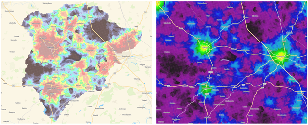
Figure 1: Local authority bands (left) vs the national score (right)
8. Next steps
The data underpinning the tool will be updated on at least a yearly basis. The Department for Transport, working with the Ministry for Housing, Communities and Local Government, Active Travel England and other key stakeholders will coordinate to explore future developments of the tool.
As new functionality or policy is developed for Connectivity Tool, we will update this suite of guidance.